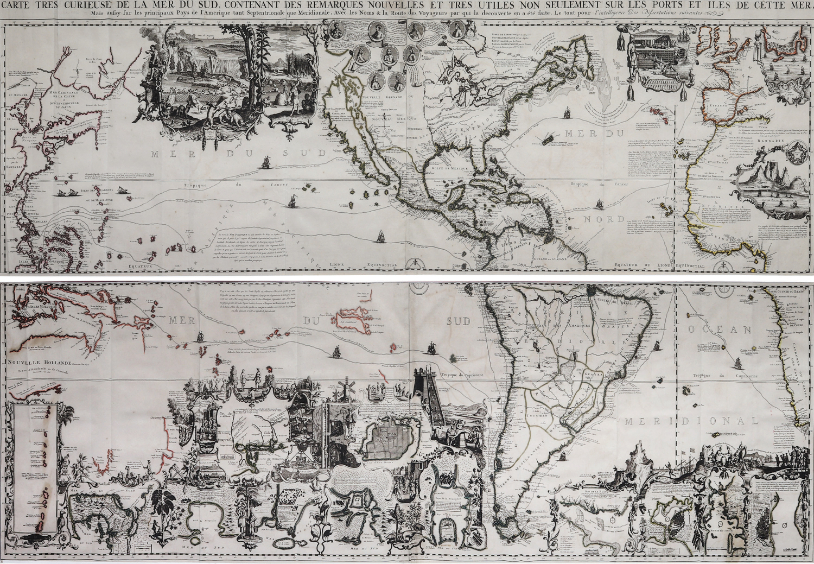
Published by Henri Abraham Chatelain, in Amsterdam in the Netherlands in 1719 or 300 years ago this map is an exceedingly rare museum piece to be found only in a few renowned libraries in the world, such as the British Museum. It has been hailed as one of the most informative, decorative, and impressive maps centered on the Pacific ever created. The map is printed from four copper plates: making the whole map of wall-sized proportions at 80.5 cm x 141 cm, a veritable encyclopedia of the world, including the Philippines. Magellan’s first circumnavigation of the globe, as recorded by his first officer El Cano is represented in this spectacular example of 18thcentury fusion of art and science. The map of the Philippines include the imaginary St. John Island off the east coast of Mindanao. It shows Palao and the Carolinas like a string of pearls on a necklace forming what seems to be an “O”. It is described in map almanacs as “one of the most elaborately engraved maps, its aim was to educate the reader in matters of geography, cosmography, topography, heraldry and ethnography, and this information-rich map is a visual celebration of the age of discovery. In the centre top of the chart are portrait medallions of the major explorers including Magellan, Columbus, Vespucci, Drake, Dampier, Jacques L’Hermite, and Schouten. There are brief descriptions of their achievements, and the tracks of their great voyages of discovery are marked. There are five voyages marked across the Pacific including that of Magellan in 1520.”
Your Inquiry was successfully sent, please wait for the reply of Leon Gallery Management.
Henri Abraham Chatelain (1684 - 1743)
Carte Tres Curieuse de la Mer Du Sud, Contenant des Remarques Nouvelles Et Tres Utiles Sur Les Ports Et Iles de Cette Mer (A Ver y Special Map of the Southern Sea, Containing New and Ver y Useful Descriptions not only on its Ports and Islands) Paris: L’Honore & Chatelain, 1719
Copper-engraved map, with fine hand coloring, printed in four
sheets joined,
32” x 56” (80.5 cm x 141 cm); mounted and framed
from the extensive multi-volume Atlas Historique