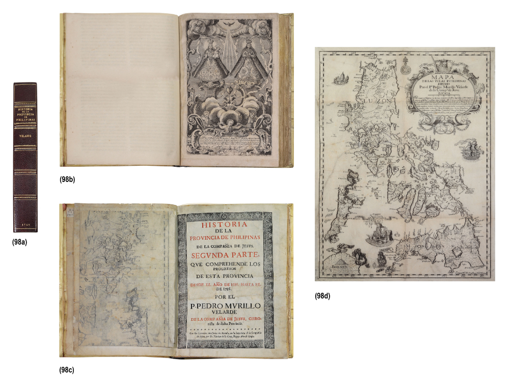
This extremely rare book published by Nicolas de la Cruz Bagay in 1749, Historia de la Provincia de Philipinas, is titled the “segunda parte,” or the sequel of a previously published history of the Philippine Jesuit province, Fr. Francisco Colín’s Labor evangélica (1663), which was considered the “parte primera” that covered Philippine history from the earliest time until 1616. Murillo Velarde’s sequel traced the colony’s history from 1616 till 1716, as indicated in the subtitle. This author also continued Fr. Colin’s outstanding work, which was the first book to contain the earliest scientific data on flora, fauna, geography, and languages of the Philippines.The first part of Murillo Velarde’s book tackles Philippine colonial history, while the second describes the conquest and missions of Mindanao. The last part deals with the conquest of the Mariana and Palau islands. The included foldout map, Mapa de las Yslas Philipinas hecho por el Padre Pedro Murillo Velarde de la Compañía de Jesús is the diminutive version of the renowned and exceedingly rare 1734 map of Murillo Velarde, Carta hydrográphica y chorográphica de las Islas Philipinas, which is known today as the ”Mother of All Philippine Maps.” One such exemplar was auctioned by León Gallery for the record price of of P46.2 million on 14 September 2019. This second edition is about a fourth of the size of the original edition and is known for its distinctively charming cartouche dominated by a lion holding aloft a banner, which is flanked on the left side by a berobed Chinese with a parasol and a Aeta with a bow and arrow, while on its right is yet another Cimarrón archer and a Moro with kalasag and spear. The bottom of the cartouche is surmounted by the famous Dos Mundos, signifying the east and west hemispheres that Spain ruled. The former is represented by an indio with his gamecock and the other by a berobed European maiden. This version of the mother map can also be easily distinguished not only by its smaller size but by the lack of traceries of sea routes and multiple compass roses, which indicated that it was truly more of a map rather than a portolan chart for use of navigators. Another distinctive feature is the representation of the Jesuit Apostle of the East, St. Francis Xavier, who rides a seashell while holding a trident like Jupiter as he rules the waves. Humorously, a tiny crab to his right returns the saint’s lost crucifix, referring to a legendary anecdote. The engraver of the map is identified on the bottom right corner with the phrase, “Lo esculpió Nicolás Cruz de la Bagay, Manila, Año 1744.” The rarity of this map can be gleaned from the inventory of Jesuit properties at the time of their expulsion from the Philippines in 1768: only one large one of 1734 was available, while only six of this very same map were at hand. This historical icon continues to be an object of fascination due to its continuing relevance. The larger version of this map was presented to the Permanent Court of Arbitration in Hague as the major cartographic and historical piece of evidence proving the connection between the Philippine mainland and Scarborough Shoal (also known as Bajo de Masinloc), which is clearly indicated in the map as Panacot island west of Zambales. The long-simmering dispute between the Philippines and China over the rights on some islands in the West Philippine Sea was ultimately decided in favor of the Philippines on 12 July 2016. The international court rendered a decision that declared that the Chinese claims could not be substantiated and that the Bajo de Masinloc was a shoal visible only at low tide and therefore could not entitle China to claim it as its exclusive economic zone. In the end the tiny island depicted in this map would lie at the very crux of an international dispute.
Your Inquiry was successfully sent, please wait for the reply of Leon Gallery Management.
P. Pedro Murillo Velarde (1696 - 1753)
Manila, 1749 (in original limp vellum binding with a modern hardbound slipcase) 419 pages Printed by D. Nicolás de la Cruz Bagay at the Imprenta de la Compañía de Jesús, Manila Includes a foldout map, Mapa de las Yslas Philipinas hecho por el Padre Pedro Murillo Velarde de la Compañía de Jesús, 1749 Also present as called for is the famous full page frontispiece engraving by Laureano Atlas of the Virgen de la Rosa of Makat i and the Virgen de la Paz y Buen Viage of Antipolo.
book: 12” x 8 1/2” x 2”
(30 cm x 22 cm x 5 cm)
map: 20 1/2” x 14” (52 cm x 36 cm)
SOLD: PHP 2,336,000
Provenance: Provenance: Private Collection, Manila