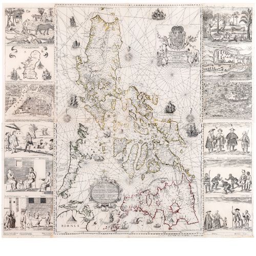
Known as “the most famous Philippine map”, the “Carta Hydrographica y Chorographica de las Yslas Filipinas” was published in Manila in 1734 by the Jesuit father Pedro Murillo Velarde.
This ‘Holy Grail’ of Philippine Maps is singularly and historically important not only because it influenced several generations of map-makers but also provided an important record of the islands, seas and moreover, the people of our country. It was also the culmination of two centuries of map-making and was the most accurate till them and long after.
The map, described in the “Mapping the Philippine Seas” catalogue, “shows coasts, towns and interior topography, and is also a sea chart with a stylized sun as the center point and four compass roses at the cardinal points of the hidden circle formed by intersecting rhumb lines. Two tracks for the Manila Galleon are shown, one around the north of Luzon and the other through the San Bernardino Strait, as well as the routes taken by Ferdinand Magellan and for trading with China.
“The title cartouche at the top of the map is embellished with the royal Bourbon coat of arms, supported by two cherubs with trumpets, with the title of the map on a cloth held by two allegorical figures bearing charts and instruments. (Carlos Quirino described these as representatives of navigation and astronomy.) Below, a second ornate cartouche, surmounted by a crowned lion wielding a sword and a candle, contains a brief history of the archipelago starting with Magellan.” There is also an economic survey of the products of the country.
Nine different types of Spanish ships are shown, including Magellan’s “Victoria” which is described as the first to have circumnavigated the world.
The entire work was engraved and printed by Nicolas de la Cruz Bagay, who was responsible for producing some two dozen books for the Jesuits in the Philippines. The map’s 12 panels showing the various inhabitants of these islands as well as the cities of Manila, Cavite and Zamboanga were intricately drawn by Francisco Suarez. Both he and De la Cruz Bagay signed and described themselves as “Indio Tagalog” and De la Cruz Bagay; ( Murillo had only the highest praise for the Filipino artisans, remarking that their work “had no equal in these Indies and could be considered elegant in Paris and Rome.”)
Moreover, it is “important not only for the size, accuracy, detail and aesthetics of the map itself, but also for the twelve detailed engravings in the two side panels.”
It is these vignettes or ‘tarjetones’ that make the complete Murillo map a marvel to behold. These 12 drawings consist of the following: (1) The sangleyes, or Chinese residents; (2) The kaffirs from Africa as well as the canarin and lascar (from India); (3) the Mestizos (or Spanish-Filipinos), Moluccans, and Japanese; (4) the Spanish; (5) Armenians, “Mogol (Mughal)”, and Indians; (6) a street scene featuring ‘Indios’; (7) country life with fruit trees and farmers; (8) exotic animals such as crocodiles, bats and snakes, more country folk; (9) a plan of Fort Samboangan (Zamboanga); (10) The Fort of Cavite showing the towns along the coast, Cavite Viejo, Binacayan, Bacoor, Parañaque, Malate and Ermita; (11) the “Ysla de Guajan” or Guam; and lastly, the walled city of Old Manila with the suburbs of San Miguel, the Parian, Sta. Cruz, Quiapo, Binondo, and Tondo are marked. There is only one bridge, the Puente de España, shown leading to southwards to Bagumbayan.
The map and these panels were engraved on eight copper plates. They were captured by the English when they occupied Manila from 1762 to 1764 and taken to England as war booty where they supposedly were deposited at the Admiralty. These precious plates are now nowhere to be found, and have been supposed “to have been rubbed down and re-used” to make other maps in the 19th century. This was “a common practice” on account of the high cost of copper according to map experts at the British Museum who conducted inquiries on behalf of Carlos Quirino.
Complete original copies, including the vignettes, are therefore exceedingly rare and are to be found in the most important repositories, including the National Library of Spain, the National Library of Frances, the Library of Congress in Washington D.C. and, now, in three private collections in the Philippines. The one currently in the Malacañan Museum (and once owned by Carlos Quirino) does not have the four panels of vignettes.
In closing, the “Mapping the Philippine Seas” catalogue states : “In his seminal book, “Philippine Cartography 1320 - 1899”, Carlos Quirino comments, ‘So important is Pedro Murillo Velarde’s map to Philippine cartography, so neat is the engraving and so faithful are the illustrations, that in all likelihood, it will continue to be reproduced periodically in the years to come.”
- Lisa Guerrero Nakpil
*Leon Gallery wishes to thank the Philippine Map Collectors Society (PHIMCOS) through its President, Jaime C. González, for providing us with information and guidance on this catalog entry.
Provenance: Provenance: Private Collection, Manila